Flight Planning
The very first part of a flight is the planning of
it. In the real world they have huge dispatch departments doing it for
you, but we are not
that fortunate. Further, in any case, as PIC you are still ultimately
responsible to ensure all is correct.
In this class we will teach you about:
- The “Where, What and When”
- How to plan and review the route
- Jet & Victor Airways
- The Weather!
- How to calculate the fuel
- What to log after the flight
The “Where,
What and When”
You can review and select a flight from the online UVA website Pilot
Center directly, you have to log in.
You can also download a
spreadsheet listing the entire
monthly
flight schedule from the VHQCC
- Downloads section. Then you could look for a very particular kind
of
flight, perhaps in a specific aircraft that you might be interested in.
Once you have selected a flight, make note of the
particulars, and then you proceed from there.
How to Plan
the Route
 This is where it
gets complicated. You can get
from A to B, dozens of ways, using different VORs, NDBs and
fixes, along different high and low altitude
airways. This is where it
gets complicated. You can get
from A to B, dozens of ways, using different VORs, NDBs and
fixes, along different high and low altitude
airways.
Most of the time you will look for help in
planning your route, and luckily, there are now many resources to
consult to find preferred routes to and from major airports, and easy
ways to load these as routes into Flight Simulator and fly them with
default aircraft. You do not need a complex payware aircraft to
accomplish all this. Unless
otherwise noted, all of the below are available without charge.
But, one thing that you should not do, is use the built-in
"auto-intelligence" in the Fllight
Simulator flight planner to create a
route. It will virtually never generate a
proper one.
Also, once and for all, you need to leave "GPS
Direct" from airport to airport
behind, that is really an absence of flight planning.
VATSIM's Simroutes
(www.simroutes.com) - This is
targeted specifically at the virtual pilot, and is a treasure trove of
preferred routes, all over the world. Not only does it give you the
route, it provides current weather reports, a detailed Nav Log that you
can print, and even a graphic showing the route. You could just copy
the
route down with pen and paper, but it is much slicker than that.
Simroutes will let you download the route electronically in a
format that Flight Simulator can import directly! Simroutes will also
let you
download the flight plans in formats that are recognized by major
aircraft add-ons.
vRoute (www.vroute.net) - This is not just a
website, but an application that you download. It has been under active
development for several years, and has now matured. It includes most of
the tools you need to plan a route. It contains a huge
database of worldwide preferred routes, weather and more. It also
interfaces with the VATSIM database and will dynamically show you the
currently active ATC, as well as ATC coverage bookings in the immediate
future,
even ATC booked along your route. Hard to believe it is freeware.
From the real world, there is FlightAware (www.flightaware.com)
- This is an amazing database containing virtually every flight
originating and/or terminating in North America. Even VFR flights by a
GA aircraft are included, as long as a flightplan is filed. It will
show you the flightplan and many other particulars. You can search the
database in a multitude of ways, by airline, aircraft or location. It
also provides real time tracking of flights, so you can fly along with
the actual United flight you are simulating! Obviously you can get a
flight plan from this site, but you need import it yourself into Flight
Simulator or the aircraft FMC you are using.
RouteFinder (rfinder.asalink.net) - gives
you full international support, it can generate a route from virtually
any origin, to any destination. It uses a built-in artificial
intelligence, rather than a straight database approach. It is generally
very
good, but sometimes can come up with an unusual route.
Fltplan.com
(www.fltplan.com)
– You have to register to use this one, but registration is free. It is
more targeted for real world GA planning, and focuses only on routes in
North America.
NAT tracks
(www.notams.jcs.mil)
- Up-to-date NAT (North Atlantic) tracks as well as Pacific tracks and
local notams. These get you across the oceans. You won't need them
until you are Cat IV or above.
Airways
Airways are a set of fixed “highways” in the sky
for aircraft. There are two general kinds that you will be using,
civilian high
altitude airways and
low altitude airways. Let’s go over their use, the following holds for
the US & Canada. Elsewhere in the world the naming conventions are
different, in addition the Flight Levels typically start much lower, as
the Transition altitudes are lower.
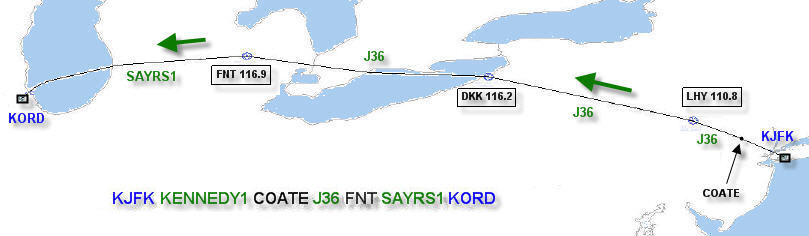
Jet-airways (ex. J164)
Jet-airways are the high altitude airways, as they
are used from FL180 (18,000ft when the baromter is 29.92) and up. You
will
find them everywhere in a complex network. Some can be followed coast
to coast, some just a few hundred miles.
The airways are defined by VORs, sometimes ADFs, and intersections.
Intersections are waypoints that do not have a station
associated with them, and are located by the intersection of two VOR
radials, hence the name. In a flight route you could find something
like this:
COATE-J36-FNT
This means you fly from COATE waypoint, and follow
Jet-airway J36 to FNT (Flint) VOR. You do not fly "direct to" FNT
(as the crow flies) from COATE, but rather fly the airway that may
zigzag back and forth a bit as it follows intermediate waypoints. Here
is the Jet airway expanded in a listing of that route, the VORs are in
bold:
COATE - LHY DGRAF MINEO REBBL
WAAKE DKK DKK23 JLGON GOOSS
FNT58 ATTIX - FNT
Obviously, it is quicker to just write J36, then
all those individual waypoints, they mean the same. Complex aircraft
will also
accept airways when inputting a flight plan, makes it much faster. In
North America NDBs may be one, two or three alpha characters, VORs are
always three alpha characters, and intersections are five alphanumeric
characters long.
You could also encounter this:
COATE-J36-J70-FNT
This is a bit more complicated, but fairly easy.
It just
means that you will pick up J36 from COATE, and where J36 and J70 meet,
you will follow J70 to FNT.
Here is something that looks complicated, but really isn't:
PLL PLL275065 FOD
This means to fly to PLL (Polo) VOR, then take
the 275 radial outbound from PLL for 065 nm, and then turn direct FOD
(Fort
Dodge) VOR. This is a common west outbound route from KORD on the ORD1
(O'Hare One) departure procedure (SID). Much more on departure and
arrival procedures below.
Victor-airways (ex. V42)
Victor-airways are the same as Jet-airways, but
for low
altitudes ranging from the ground to 17500ft. Sometimes you will find
them in a route with Jet-airways like this one:
COATE-J36-FNT-V61-ORD
Jet-airways would be used for longer flights at
higher altitudes, Victor-airways would be used for short hops at lower
altitudes or in a long flight where you will be flying at a low
altitude for a period.
Reviewing
the Route
OK, lets go to Simroutes, enter
in KJFK for
departing
and KORD for
arriving,
and presto, out comes our route.
Notice that the KENNEDY1 component is not listed. This is
because it is the only departure from JFK, and it is understood to
always be used. ORD1 at O'Hare
is another example of something that will not pop up for the same
reasons. OK, here is the route with the departure procedure (SID)
prepended:
KENNEDY1 COATE J36 FNT SAYRS1
Now what does this really mean?
Looking closely, we can split it into three parts,
departure, route and arrival:
Departure – KENNEDY1
COATE
Departure procedure (DP or SID) and the exit
point/transition. The Departure class
will go over this in detail.
Route – COATE
J36 FNT
The waypoint where you will start to follow the
airway, the airway itself and the waypoint where you will leave it. You
will only fly one airway on this flight. So, the above is a convenient
abbreviation. As shown in the Simroutes NavLog, and as already noted
above, this is what the route looks like
when expanded to include all the individual waypoints:
COATE LHY DGRAF
MINEO REBBL
WAAKE DKK DKK23 JLGON GOOSS
FNT58 ATTIX FNT
The VORs are bolded.
Together with their
frequencies, the VORs are: Lake Henry (LHY
110.80), Dunkirk (DKK 116.2) and Flint (FNT 116.90). These are bolded to
remind you that it is important that you keep track of the VORs on the
route. You should set your NAV radios to track them, and ensure that
you are correctly on course. Most airways are constructed along VOR
radials or NDB bearings.
We will go over in detail how to actually follow
all those "radials" and
"courses", and fly tracking VORs in the Navigation
class, but let us review the route.
On this flight, from COATE we travel on a course
of 300º to reach LHY (use LHY VOR, TO course 300). Once we reach
LHY,
we turn to a course of 290º (use LHY VOR, FM course 290), which
will
get us to DKK. For that leg, we are also travelling on the DKK VOR, TO
course 290, both radials map the same segment.
Leaving DKK we turn to a course of 273º (DKK
VOR, FM course 273), but this does not take us to the next VOR. Here,
some 96nm along that radial, we turn right 10º, to track a new
radial
into FNT (FNT VOR, TO course 284).
Navigating with these radials, you will cross not only the VORs but
also all the intersections noted in the flight plan.
Never just blindly follow that magenta
line, it can lead you into serious trouble. The more crosschecks you
have,
the
safer you are.
Arrival – FNT SAYRS1
FNT (Flint) VOR is the waypoint/transition where
you
will join the
arrival procedure, and the arrival procedure (STAR) itself, namely
SAYRS1. More on flying a STAR in the Arrival class.
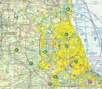
Sectional Maps
Once you have a proposed route, you may wish to have a better look at
it,
by
reviewing it on a sectional and terminal area maps. Electronically,
there are now at
least
two great sites that let you do this, but unfortunately only for the US
and contiguous Canada.
Flyagogo (flyagogo.net)
- Not only does this let you view sectional and terminal area maps, it
will let you input a flight plan and it will draw the route right on
the virtual map. It will also show you a profile view, and give you a
better idea of what elevations you will encounter enroute. It even has
weather and satellite view overlays. The one small downside is
that you can only input waypoints for the flightplan, it does not
understand airways,
unlike you do now.
SkyVector (skyvector.com)
- Another similar site, it does not take a flightplan, but it does have
charts for Alaska and shows airport weather (METARs). More on METARs
below.
You can also obtain hardcopy maps. These publications are low cost and
are
available from a variety of sources, you may wish to
buy copies for your local area. If you have room, they will be easier
to view, and will let you mark routes the old fashioned way, with
pencil and plotter.
SID/STAR Charts
Now, it is time to study the airport, departure,
arrival and the likely
runway arrival plates for the flight. You can find plates, free for the
download at myairplane.com or
airnav.com for
the U.S., and
US/Canada/UK at chartfinder.vatsim.net.
So, pick one, and look up KJFK, for the airport
details and
KENNEDY1. Then lookup KORD for the airport layout, the SAYRS1 STAR, and
then the likely runways you might be assigned for landing -- have a
look at
the
approach procedures for these. We will be looking at these in detail in
the following sections.
What about
the Weather?
Well that is
pretty important. When flght
planning, you need to
review the weather not only at the start and terminus of your flight,
but also the enroute weather. Weather for North America, Western Europe
and the northern Atlantic & Pacific is readily available at the
following sites.
METARS are a shorthand used to summarize Aviation
Weather. Where to get, and how to read a METAR is discussed in the Navigation class.
NOAA's National
Weather Service - Aviation Weather (aviationweather.gov) - This
slices and dices the weather any which way, but mainly for just the
continental US only.
NAV CANADA's -
Aviation Weather (flightplanning.navcanada.ca)
- Maybe you are flying to Canada. The advantage of this site is that it
also provides weather for the North Atlantic and Pacific.
Jeppesen Weather (jeppesen.com)
- This is a subscription product, but its web page has an array of
current weather products that you can view in demonstration. To
download or print the images, you must subscribe.
How to
calculate the fuel
Well this is all a little too easy for you now -- and that is a good
thing, as flying with too much, as well as too little fuel are critical
errors for a variety of reasons.
Unlike taking out your
personal C172 for a one hour joyride and that
$100 hamburger, fuel planning for the big birds is pretty complex. With
some exceptions, in a small aircraft you generally fill up the
tanks to full any chance you get. You do not do that with large
commercial aircraft.
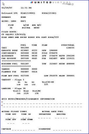
UVA's
Flight Planner and Dispatch Creator (v2.5)
does all that work for you, and really much more. It will calculate the
fuel required, warn you of any weight issues, calculate your takeoff
and landing VSpeeds, and even print off a nice Dispatch Release. This
tool is available as a spreadsheet that you can download. In addition
its full functionality is now also incorporated into the Pilot Center,
and available when you book a flight.
 First you
put together your
flight plan, and then you
turn to this excellent tool to do the rest ... First you
put together your
flight plan, and then you
turn to this excellent tool to do the rest ...
- The FPD creates a full
Dispatch page, in both the Spreadsheet & the Pilot Center
- Has complete weight & fuel data for
every
plane in the mainline and express fleet!
- At a glance, has all the
important weight and fuel burn numbers
- Calculates reasonable
and safe fuel on board numbers
- Warns if you do not have
sufficient fuel capacity for the trip, given your payload
- Warns if you will be
overweight for your expected landing weight
- You can quickly fiddle
with the plan payload, to fit the flight
- The takeoff V1, Vr & V2 (as well as Vref30 for
Boeings) speeds now available, all corrected for weight!
- Calculates the landing
Vref corrected for weight, together with an automatic wind correction
- UVA SOP flap settings
for takeoff and landing, for the entire fleet
Aren't you glad you joined up!?
Even better the FPD documentation goes into a good explanation of fuel
planning issues, and takes the mystery out of all those VSpeeds, that
really are critical for flying your aircraft.
The FPD is available for download from the VHQTD
page, under tools.
The documentation is also available separately as a quick PDF
download.
What to log
after a flight
After a successful flight, you need to file a PIREP
in order to get credit for your hours. The UVA database requires the
following bits of information. In order to file a pirep, you log into
the Pilot Center from the main
UVA website page, where you made the reservation for the flight.
When you start up your simulator, you
should set the simulator clock to before your flight is to depart. For
example if you are planning to depart at 2000z, you could set your
simulator time to 1930z. You may prefer to fly actual real world time,
or some other time of interest, all are acceptable. It is entirely up
to you. But once you start
your flight, you shouldn't play with the clock further.
Departure
gate
Should be noted before you push
back.
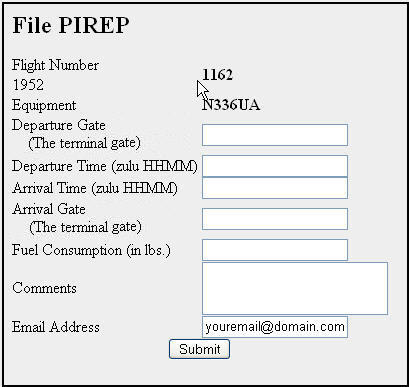
Departure
time
This is the time you release the parking
brakes and start to push back.
All times are input in GMT, or Zulu time. Do not
use
colons when entering the times, and always prepend zeros so that you
have four numeric characters for both times.
Arrival
time
The time you set the parking brakes
at your destination. You should note this time before you leave the
simulator.
Arrival
gate
Note this before you leave the
simulator.
Fuel Consumption
Before you start your engines, you
will have fueled the aircraft according to your plans. You will need
this fuel weight (in pounds) for the pirep report. When you shut down
the
engines at the gate at your destination, note down the fuel you
have left. The difference is the block fuel used, and the amount that
is requested in the pirep report. For example:
28, 008 – (final fuel count) = Block Fuel
28,008 – 6 542 = 21,466 lbs
Your Email
We need a current email address to communicate
with you, please ensure that the email address of record is correct
went submitting your pirep.
|